Highways & Transport
Strategic Transport Context
The Birkenhead 2040 Framework sets out Wirral Council’s agenda to deliver transformational change across the Birkenhead urban area. The 2040 Framework confirms that the success of this transformational urban change is the removal, alleviation, or reallocation of major infrastructure that severs and creates barriers between places and communities across the area. This includes simplifying the “concrete collar” of infrastructure that currently surrounds the town centre, its rail stations and tunnel plazas.
Removal of the flyovers
Currently Borough Road (A5227) and Queensway Tunnel flyovers split the Urban Village and create a barrier to movement between the north and south of the site, severing the town centre from its residential neighbourhoods to the south. The Birkenhead 2040 Framework says the flyovers have:
“long created a visual blight and physical severance to the core of Birkenhead. The Framework advocates the removal of the flyovers as paramount to the wider regeneration framework, including realising aspirations for Birkenhead Central, Central Station and Hind Street Urban Village. Indeed, without removal of the flyovers and addressing the extent of associated land including marshalling land, tollbooths, over-engineered roads and roundabouts, it will be impossible to properly connect Birkenhead’s communities in the future.”
The flyover removal is recognised in draft policy RA 5 Hind Street and St Werburgh’s Regeneration Area of the new Local Plan which requires that plans for the Urban Village incorporate proposals for a new highway network to accommodate changes arising from the removal of the Borough Road (A5227) and Queensway Tunnel flyovers.
The planning application will seek permission for the removal of the flyovers which if granted will be followed by a Highways Stopping Order prior to the flyovers being removed. The planning application will set out proposals for the phased removal of the flyovers and replacement highway network to accommodate changes as a result.
Walking and Cycling
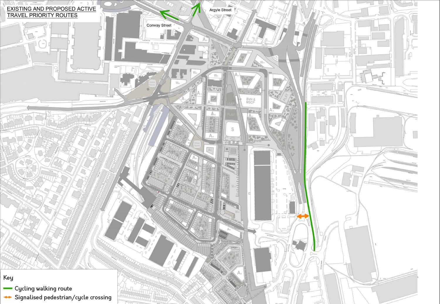
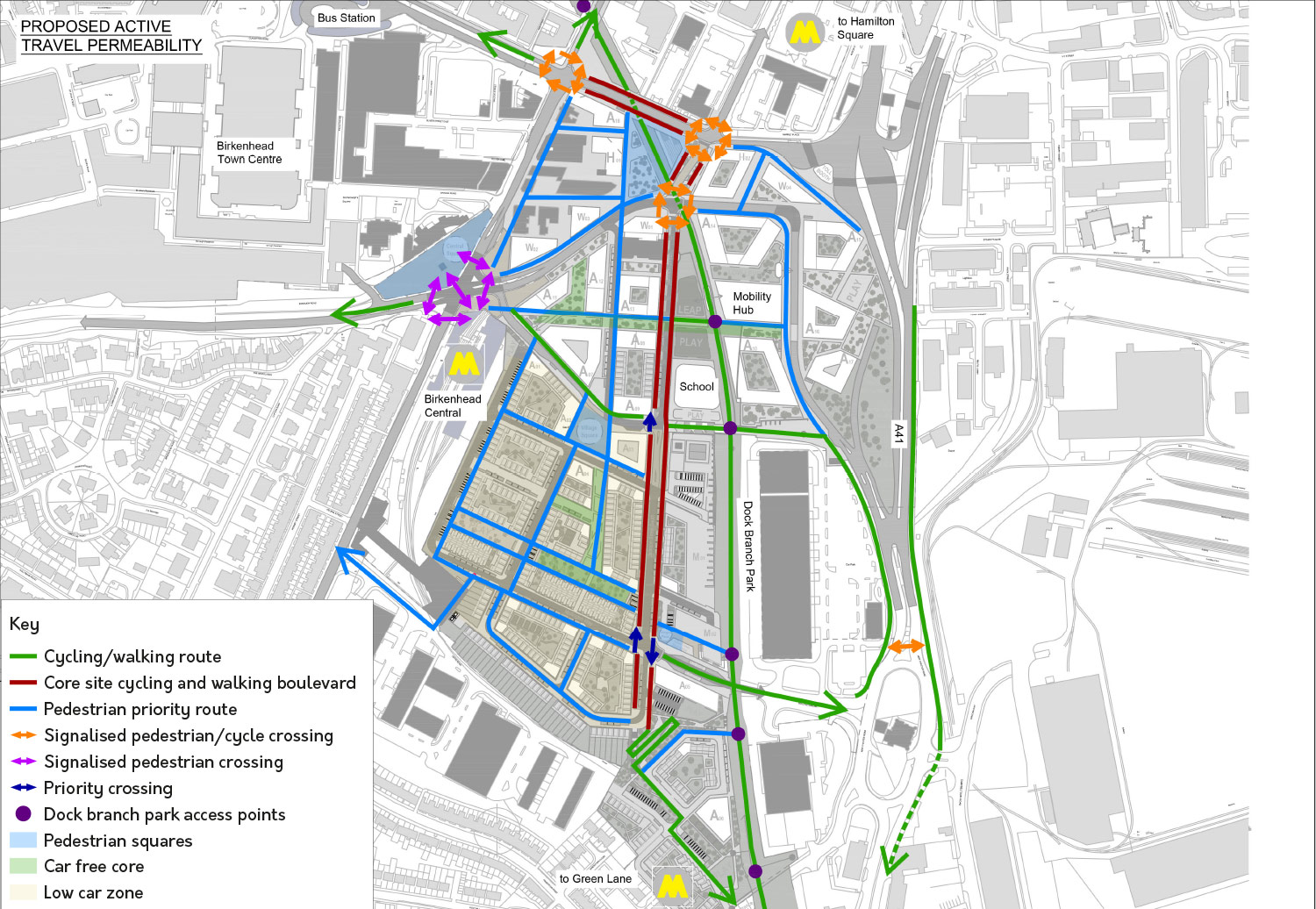
There is already a comprehensive series of non-car routes that run to and through the town centre. However, these are not well used because they have become so inter-woven with the over-engineered roads referred to in the Birkenhead 2040 Framework. Removing these barriers and discouraging drivers who don’t need to drive across Birkenhead town centre will encourage walkers and cyclists to use these existing non-car routes.
Plans for the Dock Branch (North and South) will create a new cross-town pedestrian and walking corridor along a former railway line, connecting regeneration areas with the town centre, railway stations and the Wirral Waters development to the north.
The Urban Village proposals also provide new walking and cycling routes, improved public realm and wayfinding. This will help establish a strong hierarchy of streets and spaces that prioritise pedestrians and cyclists and provide them with links between the new development plots, the rail stations, and the wider Birkenhead town centre.
Existing Travel
Proposed Travel
Public Transport
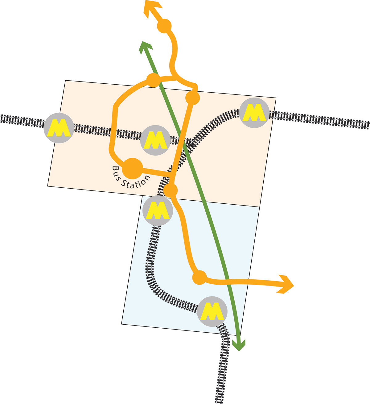
The new urban village is exceptionally well served by public transport. It sits between Birkenhead Central and Green Lane Merseyrail stations, with fast, frequent services to Liverpool, Chester and Ellesmere Port and onward connections across Merseyside, the North West and the rest of the country. Liverpool is just five minutes away by train. Birkenhead bus station, with services across Wirral and to Liverpool, is also just a few minutes’ walk away, and buses on nearby Argyle Street South, Hinderton Road and New Chester Road offer direct routes to Arrowe Park, Clatterbridge, New Brighton, Liverpool, Eastham, Cheshire Oaks and Chester.
The illustrative masterplan for the new urban village shows new bus stops to support new bus routes connecting the urban village and the town centre to the north with Mollington Link in the south. The new Mollington Link to Hind Street route will also accommodate bus servcies currently using the flyovers. These stops could also be served by Wirral Council’s proposed new mass transit system, with a route connecting Wirral Waters, the town centre and the village. Improvements to the public realm outside Birkenhead Central will create an enhanced sense of arrival at one of the key stations serving the town centre.
Car Movements
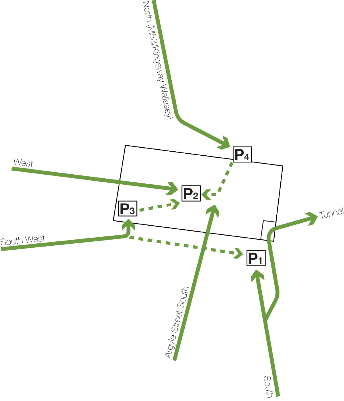
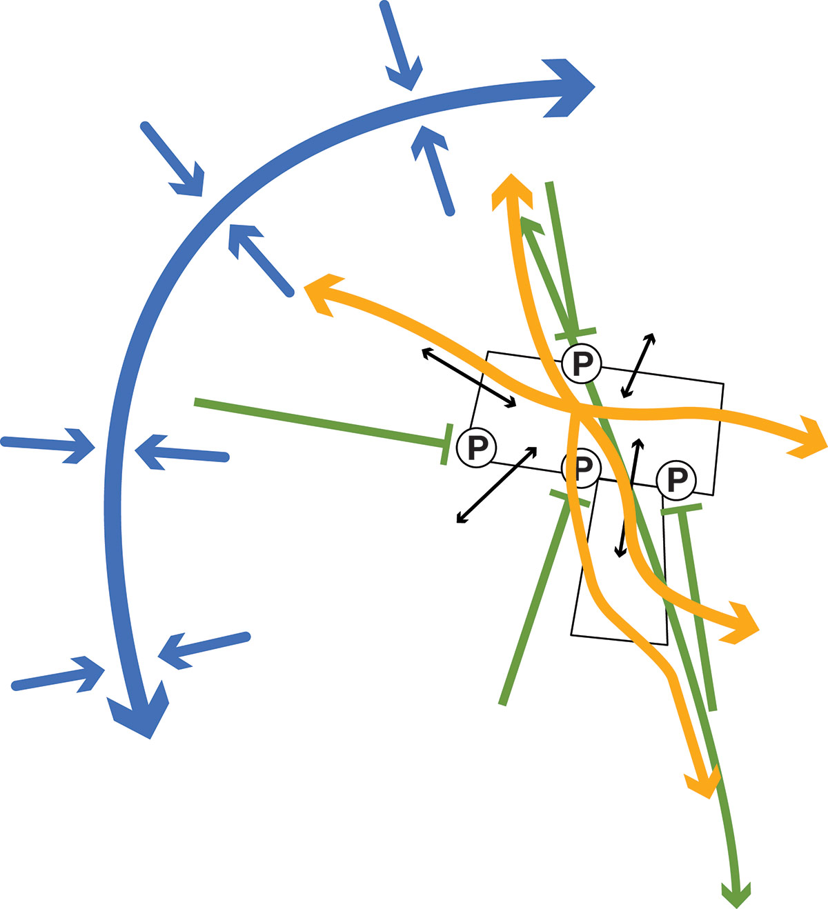
The urban village proposals have been designed using a “decide and provide” approach when it comes to private car use rather than the traditional “predict and provide” approach, with the aim of achieving lower dependency on the private car. As well as using strategic routes to redirect through traffic away to the M53 corridor a critical element of the town centre thinking needs to be to remove the ability for unnecessary through traffic within the core of the town centre. The ‘Laird Grid’ lends itself to permeability and at present providing multiple route options across it makes it too easy to travel through by cars, at the expense of public transport and active modes. In simple terms motorised through movement is currently being prioritised over more active travel modes and placemaking. Those driving to the town centre along historic radial corridors can help reduce their impact by using ‘interceptor car parks’ at their first point of arrival, as shown in the following diagram.
High-quality walking and cycling routes from these interceptor points will make the onward journey to the final destination simple, more practical and enjoyable. The illustrative masterplan designs in this approach by using traffic signals and road crossing points located on pedestrian desire lines to create high-quality walking routes into the town centre.
Car Parking
Of course some people will still choose to or have to travel by car, however the provision for parking within the proposed development is deliberately below the council’s maximum standards, to encourage the shift to more sustainable journeys, and to suit the lifestyles of people who will chose to live in the Urban Village. Accessible parking has been carefully considered and is provided at key locations across the urban village to ensure all elements of the proposals are within close proximity of these. Limited on-street and undercroft parking parking will be provided for the new homes, and residents will be able to use the multi-storey car park, which will act as a traffic interceptor by stopping vehicles entering the town centre for parking purposes. This multi-storey car park will also provide parking capacity for the non-residential uses of the masterplan, including workplace, retail and leisure. The multi storey car park will also serve as a “mobility hub” combining the car park with sustainable transport options like car hire, car club, cycle hire, EV charging facilities and exploring options for parcel delivery or pick up.